Districts of Himachal Pradesh : A minor introduction to all districts
![]()
Districts of Himachal Pradesh: Some quick facts to remember
USEFUL FOR UPSC, HPAS, HAS, HIMACHAL ADMINISTRATIVE SERVICES , GOVERNMENT EXAMS IN HIMACHAL PRADESH, HIMACHAL GK ASPIRANTS
District in Himachal Pradesh: Himachal Pradesh is located at 30 degrees and 22 minutes 33 degree 12 minutes on North latitude and 75 degrees 47 minutes to 79 degrees 4 minutes on East longitude in which we have 12 beautiful districts of Himachal Pradesh. Here we are citing few quickies about all the districts of the state. But before that some information is to be shared :
Himachal as Chief Commissioner Province was found on 15th of April 1948. There were 4 districts back then: Chamba, Sirmaur, Mandi and Mahasu
- Chamba and Sirmaur princely states were merged into Himachal without altering their boundaries.
- Mandi and Suket princely states were merged to form Mandi district.
- Mahasu was created by merging 26 princely states.
- Bilaspur was added to Himachal Pradesh on 1st July 1954, it was part C state before that.
- On May 1st 1960 Kinnaur was carved out of Mahasu district.
- On Nov 1st 1966 Kangra, Lahaul and Spiti and Kullu were added.
- On 1st September 1972, Hamirpur and Una were craved out of Kangra. Solan was also created and Mahasu was renamed Shimla.
Let’s start alphabetically
- Bilaspur: Headquarters located in Bilaspur town. The district has an area of 1,167 km2 and a population of 382,056 (2011 census). As of 2011, it is the third least populous district of Himachal Pradesh after Lahul and Spiti and Kinnaur. Languages spoken are Kehluri (Bilaspuri) Hindi and Punjabi. It’s well known for Govind Sagar Lake and Bhakhra Dam among many other things and places.

- Chamba: Headquarters are located in Chamba town. area of 6528 square kilometres. Population 519080(2011 census). Its well known for its international Minjar fair, Manimahesh Yatra among many other things. Many tribes are found here with most notable one to be Gaddi. Gaddi,Chambyali and Hindi are frequently spoken in this district.

- Hamirpur: Headquarters are located in Hamirpur itself and it has an area of 1118 square kilometres. AS of 2011, 464,768 people reside in this district. Hamirpur is well known to be the most literate district of Himachal. Sujanpur Tira is among many places of importance in this small district. Their language is a mix of Kangri and Mandyali but most of the district is fluent in Hindi as well. This district has the highest density of road in the whole state.

- Kangra: Headquarters are in Dharamshala, Kangri Hindi and even Punjabi are spoken in this district, being the headquarters of exiled Tibetan government, Tibetan is also spoken. their area is 5739 square kilometres and population wise, its the number one district of Himachal Pradesh, coming fourth in term of area. Many places are of national tourism importance in Kangra. As of 2011 15,10,075 people lived here.

- Kinnar: Headquarters are in Rekong Peo and an altitude of 2290 meters and area of 6401 square kilometres. Kinnauri or Hamskad, Sangnaur, Jangiam, Shumecho are major languages among many others which are spoken here. Many Valleys are named after villages like Satluj and Baspa or Sangla valley. They are fair-festival dominated society. Kinnaur has higher sex ratio than even the national average. AS of 2011, 84121 people lived here.

- Kullu: Headquarters located in Kullu on an altitude of 1219 meters. Kulluvi and Hindi are most spoken languages here. With 5503 square kilometres area, Kullu is an important tourist destination, mainly known for Manali among other places. as of 2011, 437903 people lived here. Kullu. On 7 Oct 2014, Kulluvi Natti world record was set at Dhalpur Maidan, 8760 women danced to create this record. Kulluvi Dusherra also holds great importance in and outside the country.

- Lahaul Spiti: Headquarters located in Keylong at 3165 meters of altitude. Two valleys are linked by Kumzam pass. Bhoti, Manchat,Changsa and Gaheri are spoken here. A 13833 square metres of the area is a living museum. Major rivers are Chandra, Bhaga, Pin and Spiti.Fagli festival and Pauri fair hols much importance in the valley as of 2011 only 31564 people lived here.

- Mandi: Headquarters are in Mandi and Mandyali, Suketi and Hindi are most spoken. The district receives the highest rainfall in Himachal Pradesh of 2029 mm. Rewalsar, Prashar, Kamrunag lakes are visiting. 999,777 people lived here as of 2011. Shivratri fair of Mandi is of world level importance. The total area of Mandi is 3951 square kilometres. Its also called Choti Kashi or Varanasi of hills by many.

- Shimla: Headquarters are in Shimla. Situated at 2206 m altitude, its the winter capital of the state and also called the queen of Hills. Keonthali, Kochi, Brari, Mahasui, Hindi, Punjabi and many other languages and dialects are spoken here. The 6 time CM Mr Virbhadra Singh comes from this district. Shimla is the hub of apples all over the nation and also very well known for its scenic beauty. as of 2011 814010 people lived here in 5131 square kilometres area.

- Sirmaur: headquarters at Nahan and situated at 933 meters altitude, Sirmauri and Hindi are widely spoken here. 2825 squares kilometres of the area have many worth visiting places like Nahan, Renuka etc. The Renuka fair is of much importance in this place. AS of 2011 529855 people reside in this district.

- Solan: Headquaters in Solan, this place is the hub of mushroom farming and modern hub of education in Himachal Pradesh. Located in 1936 square kilometres, this district has countless universities and colleges. Bhagati, Handuri and Hindi are commonly spoken languages and Thodo dance is what represents this district the in true sense. Largest industrial area of Himachal is also in this district in Baddi and Nalagarh. As of 2011, 580320 people lived here.

- Una: Headquarters in Una and situated at an altitude of 750 meters. Punjabi and Hindi are mostly spoken here. 521,173 people live here as of 2011 in an area of 1549 square kilometres. Situated at the borders of Himachal Pradesh, this district has close resemblance with Punjab.

Now for the wrap, there are few more facts given below for a quick read.
- Largest District (Area wise) – 1. Lahul and Spiti 13841, 2. Chamba 6522, 3. Kinnaur 6401, 4. Kangra 5739, 5. Kullu 5503
- Percentage of Child – 1. Chamba 13.55%, 2. Sirmaur 13.14% 3. Solan 11.74%, 4. Kullu 11.52%, 5. Una 11.36%/li>
- High Density – 1. Hamirpur 407, 2. Una 338, 3. Bilaspur 327, 4. Solan 300, 5. Kangra 263
- Top Population Growth – 1. Una 16.26%, 2. Solan 15.93%, 3. Sirmaur 15.54%, 4. Kullu 14.76%, 5. Kangra 12.77%
- High Literacy – 1. Hamirpur 100%, 2. Una 87.23%, 3. Kangra 86.49%, 4. Blaspur 85.87%, 5. Solan 85.02%
- High Sex Ratio – 1. Hamirpur 1050, 2. Kangra 1012, 3. Mandi 1007, 4. Chamba 986, 5. Bilaspur 981
| Area of Himachal Pradesh | 55673 Sq km |
| Population of Himachal Pradesh | 6,864,602 |
| Males Population | 3,481,873 |
| Females Population | 3,382,729 |
| Population density | 123 |
| Sex ratio | 972 |
| Rural population | 6,176,050 |
| Urban population | 688,552 |
| Scheduled Caste population | 1,729,252 |
| Scheduled Tribe population | 392,126 |
| Literacy rate | 83.78% |
| Male literacy | 90.83% |
| Female literacy | 76.60% |
| Capitals | Shimla, Dharamshala |
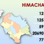
| Districts | 12 |
| Sub-divisions | 62 |
| Tehsils | 149 |
| Sub-tehsils | 35 |
| Developmental blocks | 78 |
| Towns | 59 |
| Panchayats | 3,226 |
| Panchayat smities | 77 |
| Zila parishad | 12 |
| Urban local bodies | 49 |
| Nagar nigams | 2 |
| Nagar parishads | 25 |
| Nagar panchayats | 23 |
| Census villages | 20,690 |
| Inhabited villages | 17,495 |
| Health institutions | 3,866 |
| Educational institutions | 17,000 |
| Motorable roads | 33,722 km |
| National highways | 8 |
| Identified hydroelectric potential | 23,000.43 MW |
| Potential harnessed | 10,264 MW |
| Food grain production | 1579,000 tonnes |
| Vegetable production | 900,000 tonnes |
| Fruit production | 1,027,000 tonnes |
| Per capita income | 130,067 (2015–16) |
| Social Security pensions | 237,250 persons, annual expenditure: over ₹ 600 million |
| Investment in industrial areas | ₹ 273.80 billion, employment opportunities: Over 337,391 |
| Employment generated in government sector | 80,000 |
We might have missed many things, which we will add on in our upcoming articles. Comment whatever we missed, share it with your friends and don’t forget to follow us on Facebook, Instagram, Youtube and Twitter. We will be posting more of such content.
Want to share your story with the world? Want to volunteer from your area? Don’t worry, you can always contact us on wearehimachali@gmail.com or drop a WhatsApp message on 9882837038.

Follow us to increase your knowledge about Himachal. Our updates are about events, songs, videos, history and every important thing about Himachal but above all, EDUCATION! Come here for free mock tests and lessons. 🙂
Feel free to drop a whatsapp on 9882837038
Kindly rectify the mistake-
SHIMLA is the summer capital of the state not the winter capital
Winter capital is Dharamshala.